Overview
Salatiga is a city located in the Central Java province of Indonesia. It functions as an independent administrative unit, specifically an enclave entirely surrounded by Semarang Regency. This unique geographic positioning places the city strategically between the larger urban centers of Semarang and Surakarta. The municipality is an integral component of the broader Semarang metropolitan area, contributing to the regional connectivity and urban dynamics of north-central Java.
The city covers a total land area of 54.98 square kilometers. According to the 2020 Census, the population was recorded at 192,322 residents. Subsequent official estimates indicate that the population grew to 198,971 by the middle of 2024. These demographic figures reflect the steady growth of the urban center within its defined administrative boundaries.
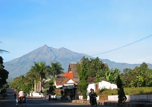
Salatiga is situated at an elevation of 450 meters above sea level. This topographic feature significantly influences the local environment, resulting in a relatively cool climate compared to the surrounding lowland plains. The city lies at the foot of two prominent volcanic peaks: Mount Merbabu and Mount Telomoyo. These geological formations define the northern and eastern horizons of the urban landscape, providing a distinct mountainous backdrop to the city's development.
The official languages used in Salatiga are Javanese and Indonesian. Javanese serves as the primary regional tongue, reflecting the cultural heritage of Central Java, while Indonesian functions as the national lingua franca for administration, education, and commerce. The city operates within the Asia/Jakarta time zone, aligning with the standard timekeeping for the western half of the Indonesian archipelago.
Etymology
Etymology
The name Salatiga is derived from the Javanese language, reflecting the region's deep historical and cultural roots within Central Java. The term is composed of two elements: "Sala" and "tiga". The first part, "Sala", is linked to the goddess Trisala, a significant figure in local mythology and Hindu-Buddhist traditions that influenced the Javanese archipelago. Trisala is often associated with prosperity and fertility, suggesting that the settlement was originally viewed as a blessed or fertile land under her protection. The second part, "tiga", translates directly to "three" in Javanese. This numerical component indicates a tripartite structure or a grouping of three distinct entities, which could refer to three villages, three hills, or three administrative divisions that formed the early core of the settlement.
Local tradition attributes the founding and naming of the area to Ki Ageng Pandanaran, a revered figure in Javanese history known for his role in the spread of Islam in Central Java. According to the story, Ki Ageng Pandanaran established the settlement and named it Salatiga to honor the goddess Trisala while acknowledging the three-fold nature of the community he organized. This etymological origin highlights the syncretic nature of Javanese culture, where indigenous beliefs and later religious influences often coexisted and merged. The name thus serves as a linguistic marker of the city's historical development, preserving the memory of its mythical and historical foundations. The connection to Ki Ageng Pandanaran also underscores the importance of local leaders in shaping the identity of settlements in the region, as their names and stories often became embedded in the geography and nomenclature of the areas they influenced.
The linguistic structure of the name Salatiga follows common patterns in Javanese toponymy, where names often describe physical characteristics, historical events, or mythological associations. In this case, the combination of a divine reference and a numerical descriptor provides a concise yet informative label for the location. The use of "Sala" as a prefix or component in place names is not uncommon in Java, reflecting the widespread veneration of the goddess Trisala in pre-Islamic and early Islamic periods. Similarly, the inclusion of "tiga" suggests a deliberate organizational principle, indicating that the settlement was not a random aggregation of dwellings but a structured community with defined boundaries or divisions. This etymological background offers insight into the social and cultural dynamics of the area during its formative years, revealing how language and belief systems interacted to create a distinct local identity. The name Salatiga, therefore, is not merely a geographical label but a historical document encoded in words, preserving the legacy of the goddess Trisala and the founder Ki Ageng Pandanaran for future generations.
History
Early History and the Monolith of Plumpungan
Archaeological evidence points to a significant early settlement in the region, marked by the Monolith of Plumpungan. This stone monument dates back to 750 AD, indicating that the area was inhabited and held cultural or administrative importance during the early Javanese period. The presence of such a structure suggests that the local population maintained distinct traditions and possibly engaged in trade or religious practices that left a lasting physical record. The monolith serves as a key reference point for understanding the pre-colonial development of the area, which was likely influenced by the broader political and cultural shifts occurring in Central Java at the time.
Dutch Colonial Era and Administrative Evolution
During the Dutch colonial period, the region underwent significant administrative changes that shaped its modern identity. The area was integrated into the colonial administrative structure, which often reorganized local territories to facilitate governance and resource extraction. These changes included the establishment of new administrative boundaries and the introduction of colonial infrastructure, which connected the region to larger urban centers. The colonial influence also brought about shifts in local economy and society, as the area became part of a broader network of trade and administration under Dutch rule. These developments laid the groundwork for the city's later status as an independent administrative entity.
Modern Administrative Status
In the post-colonial era, the area continued to evolve administratively. It eventually became an independent city, enclaved within Semarang Regency. This status reflects the region's distinct identity and its role within the larger Central Java province. The city's location between Semarang and Surakarta has historically influenced its development, positioning it as a key part of the Semarang metropolitan area. The administrative changes over time have helped define the city's boundaries and governance structure, contributing to its current form as a distinct urban center within the province.
Geography and Climate
Topography and Elevation
The terrain of Salatiga is defined by its position at the foot of Mount Merbabu and Mount Telomoyo. This elevated location, situated at 450 meters above sea level, significantly influences the local environment. The city is administratively an independent city enclaved within Semarang Regency, placing it geographically between the cities of Semarang and Surakarta. This strategic positioning within Central Java province contributes to its integration into the broader Semarang metropolitan area. The surrounding volcanic landscape shapes the topography, creating a distinct physical setting compared to the lower-lying coastal plains of the region.
Climate Characteristics
Administration and Demographics
Administrative Structure
Administratively, the municipality functions as an independent city, a status that distinguishes it from the surrounding regencies within Central Java. The urban area is geographically enclaved entirely within Semarang Regency, creating a distinct political boundary that separates the city's governance from the broader rural administration. This enclave configuration places the municipality between the larger urban centers of Semarang and Surakarta, integrating it into the wider Semarang metropolitan area. The administrative autonomy allows for localized governance structures tailored to the specific needs of the urban population, separate from the regency-level decisions that affect the surrounding countryside.
Demographic Statistics
Population figures reflect the steady growth of the urban center over recent years. The 2020 Census recorded a total population of 192,322 residents living within the municipal boundaries. Subsequent official estimates indicate continued demographic expansion, with the mid-2024 estimate placing the population at 198,971. These statistics highlight the city's role as a growing residential and administrative hub within the province. The density of the population is distributed across the 54.98 km² area, contributing to the urban character of the region. Demographic data from the most recent census provided in available sources serves as the primary baseline for understanding the scale of the municipality's human geography.
Social Composition
The social fabric of the municipality is shaped by its location within the Javanese cultural sphere. Javanese and Indonesian serve as the official languages, facilitating communication across different social and administrative levels. The linguistic landscape reflects the broader regional trends in Central Java, where Javanese dialects often coexist with the national language. Religious and ethnic composition details are influenced by the historical settlement patterns and the city's position as a transit and administrative node between Semarang and Surakarta. The elevated position of the city, situated at the foot of Mount Merbabu and Mount Telomoyo, has historically influenced settlement distribution and community formation. The relatively cool climate associated with the elevation of 450 meters above sea level also plays a role in the local lifestyle and community activities. The integration of the city into the Semarang metropolitan area further influences the demographic dynamics, drawing residents from the surrounding regency for work and education.
Economy and Infrastructure
Economic and Industrial Landscape
The economic profile of Salatiga is significantly influenced by its integration into the broader Semarang metropolitan area. As an independent city enclaved within Semarang Regency, the municipality leverages its strategic position between the major urban centers of Semarang and Surakarta to facilitate trade and labor mobility. This geographic placement supports a diverse range of economic activities, ranging from local commerce to light industry. The city's status as part of the metropolitan region encourages economic spillover effects, where businesses and residents benefit from the interconnected markets of the surrounding areas.
Transportation Networks
Transportation infrastructure in Salatiga is designed to connect the city with its neighboring urban centers, Semarang and Surakarta. The city's position between these two major cities makes it a key node in the regional transportation network. While specific details about toll roads and terminals are not provided in the grounding data, the city's integration into the Semarang metropolitan area implies a well-developed road network that facilitates daily commutes and freight movement. Public transportation likely plays a crucial role in connecting different parts of the city and linking it to the surrounding regions.
The city's administrative structure as an independent city enclaved within Semarang Regency also impacts its transportation planning. This unique administrative setup requires coordination with the surrounding regency to ensure seamless connectivity. The presence of Mount Merbabu and Mount Telomoyo adds a geographical dimension to transportation routes, with roads likely winding through the foothills to connect different neighborhoods and towns within the city.
Public Utilities
Public utilities in Salatiga are essential for supporting the daily lives of its residents and the functioning of its economy. The city's population, which was recorded at 192,322 in the 2020 Census and estimated at 198,971 in mid-2024, requires a robust infrastructure to provide services such as water supply, electricity, and waste management. The city's elevation and proximity to mountains may influence the design and operation of these utilities, particularly in terms of water sourcing and drainage.
The relatively cool climate and the city's location at the foot of Mount Merbabu and Mount Telomoyo also play a role in shaping the public utility landscape. For instance, the availability of water resources from the mountains may support the city's water supply system. Additionally, the city's integration into the Semarang metropolitan area may allow for shared utility infrastructure, enhancing efficiency and reliability. The city's administrative independence ensures that local authorities have the flexibility to tailor utility services to the specific needs of the population.
Culture and Tourism
Cultural Landscape and Education
The cultural identity of the municipality is deeply intertwined with its history as a significant educational hub. The presence of numerous academic institutions has fostered a demographic characterized by students and academics, influencing local social dynamics and consumer patterns. This educational focus supports a vibrant campus culture that extends into the broader community, creating an atmosphere distinct from the more industrial or agricultural profiles of neighboring areas. The concentration of learning centers attracts young adults from across the province, contributing to a dynamic social environment.
Tourism and Natural Attractions
Tourist attractions in the area are largely defined by its natural geography. The city sits at the foot of Mount Merbabu and Mount Telomoyo, two prominent volcanic peaks that offer significant opportunities for hiking, trekking, and nature observation. These mountains serve as primary draws for visitors seeking outdoor recreation and scenic views. The relatively cool climate, a direct result of the city's elevation, makes the area a popular retreat for those escaping the heat of the surrounding lowlands. This climatic advantage supports tourism activities that rely on comfortable outdoor conditions.
Frequently asked questions
What is the population of Salatiga?
Salatiga had a population of 192,322 at the 2020 Census. The official estimate as of mid-2024 was 198,971.
Where is Salatiga located?
Salatiga is located in Central Java, Indonesia, between the cities of Semarang and Surakarta.
What is the climate like in Salatiga?
Due to its elevated position at the foot of Mount Merbabu and Mount Telomoyo, Salatiga has a relatively cool climate.
What is the administrative status of Salatiga?
Salatiga is an independent city (kota) within the province of Central Java. It is enclaved by Semarang Regency and is part of the Semarang metropolitan area.